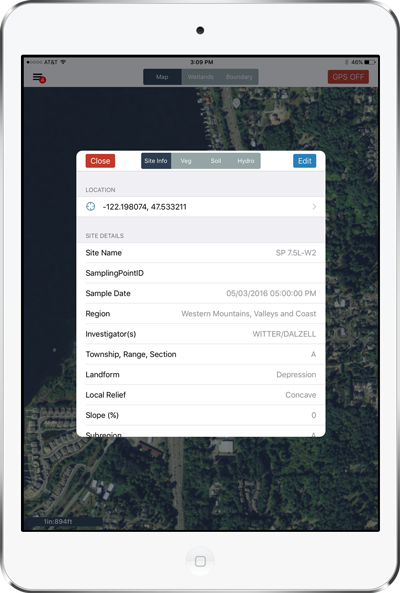
The Details
Fen runs on Apple iPads and utilizes the Esri Runtime Software Development Kit (SDK) for iOS to provide mapping
capability and seamless integration with the geodatabase schema already established for wetland determinations.
Fen works in a disconnected environment without the need for 4G/LTE cellular data connection.
GPS location data is captured either from the iPad’s internal GPS or via a Bluetooth connected sub-meter GPS unit.
Photos taken with the iPad are directly related to data in the app. Data is stored on the device throughout the
workday. Once field personnel return to the office in the evening an initial quality control check is performed
using tools integrated into the application. Data is then is uploaded directly to an HDR database server, using
Esri’s ArcGIS for Server technology. The data is made available via a secured web site for HDR (and/or other sub
consultants/client if required). The web app serves as the central hub for tracking project status, performing QC
reviews, reporting and generating project outputs.
The web app also includes additional project management and configuration capabilities. Wetland task leads define project settings in the web app, which are then reflected on the mobile device. These features include the ability to create a new project, define USACE regions, assign field users and customize plant lists. The mobile app is updated to consume these configurations and allow field users to log in using their HDR credentials and see projects they are authorized to edit.